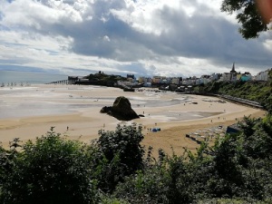
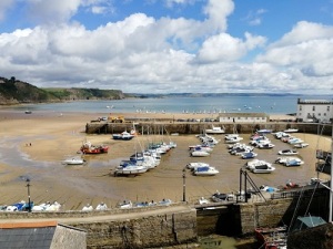
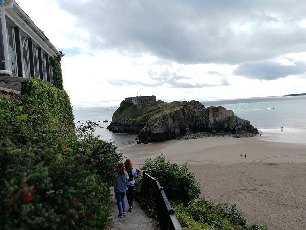
It was only a few miles to Tenby (see photos of harbour above) which several people had told me I must not miss and Route 4 went past the entrance way to the Castle. The most impressive feature of the Castle was its situation on top of a rocky headland with a narrow approach to the Castle gate. Going through I was able to obtain a magnificent view including St Catherine’s Fort (next photo), a Napoleonic Fort dating to about 1870. There was nothing spectacular about the Castle: a watchtower and the remains of some of the walls. Its history was similar to others I had seen, a wooden Norman Castle replaced in the 13th century by a stone Castle, but Tenby started to fall into disrepair quite early. In 1644 Tenby fell to the Parliamentarians after a fierce bombardment but later became a Royalist Stronghold.
The town fortifications are impressive and from the Castle you enter the town through the surviving West gate known as Five Arches (next photo) and then hit the tourists flooding the pedestrianised streets. It was difficult even pushing the bike through them. It was a picture postcard town, with everything for the visitor, many of whom would have come from the numerous caravan sites in the area.

When I was standing looking at the scene, a middle aged man spoke to me and asked if I was touring and then asked pertinent questions about my setup and it became clear that, although local, he did a lot of touring himself and so then mentioned “Warm Showers”. This is an informal arrangement and cyclists in the scheme – www.warmshowers.org will put up overnight other touring cyclists in the scheme. There is no formal charge. Jim, my friend who helped me buy my touring bike, is a member. It is rather expected that you exchange reminiscences. The touring local said that a lot of cyclists he had were Americans as Americans like to go around a country keeping near to the coast and some did not say much. He also gave me directions to get out of town avoiding the crowds, which involved going through a churchyard.
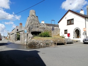
The route took me out of the town along tall town walls (see next photo) and I headed up into the hills again. After a few miles I came into St. Florence and on the cross roads saw a strange structure of a tall chimney and hearth (next but one photo). Stopped and saw several old stone houses and another chimney. l was looking at it when someone from the village passed so asked her about it and she said it was a Flemish chimney and the village had Flemish connections in the past. Apparently they are a local architectural style often later additions to old houses.

After a downhill run through narrow lanes, I suddenly emerged into Pembroke which seemed to consist of one long and very busy high street as traffic headed towards Pembroke Dock or Pembroke Bridge. The cycle route only stayed on a cycle lane along side the road for a short distance before diving down a little lane after passing a pub/cafe. This was ideal as it had a narrow section fenced off in front where I could leave the bike by a window, with a table inside where I could keep my eye on it. Unfortunately, the table was occupied by customers eating cake so I headed further down the rather scary street before giving up but on returning found that the customers had gone and secured the bike and took the table. The premises were small, a room in the front which was used as a cafe with a counter for ordering the scrumptious looking cakes . There was a narrow passage to a slightly larger room at the back used as a bar and a very friendly proprietor who did everything.
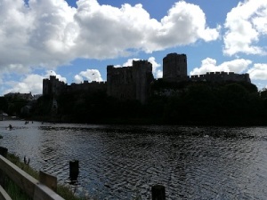
Much refreshed, I headed down the little lane which eventually took me round the castle pond and then moat of Pembroke castle. The castle was magnificent on its sunny side and then, on its shady side, impenetrable behind its wide moat.

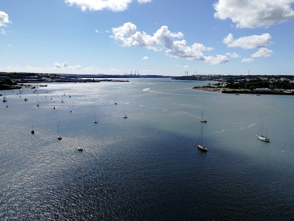
The cycle route quickly met the busy A477 but I was able to follow a cycle path most of the way towards the Pembroke Bridge. This was high above the water with a magnificent view of the higher reaches of Milford Haven with its docks and, in the distance the important oil refinery which looked out to the Atlantic and was the first stop in Britain for tankers from the West.
Route 4 then takes you along the cycle path over the bridge and almost immediately down and on to an old railway line. It was an idyllic late afternoon ride, a river to one side, trees on both banks, in the warm evening sunshine for about seven miles to Haverfordwest where I hit the evening rush hour. I had no choice but to join it as I neared the centre of the town and, finally, up a grim looking High Street to the Mariners Hotel.
